

– M. Moore

– M. Moore

– M. Moore

– H. Harbord

– H. Harbord

– H. Harbord

– H. Harbord

– H. Harbord

– H. Harbord

– H. Harbord

– H. Harbord

– H. Harbord

– H. Harbord

– H. Harbord

– H. Harbord

– H. Harbord

– H. Harbord

– H. Harbord

– H. Harbord

– H. Harbord

– H. Harbord

– H. Harbord

– H. Harbord

– H. Harbord

– H. Harbord
Bute Inlet Epic
by Rose Marie Williams, 8 June 2017.
After filling up with coffee and cinnamon buns from Nancy’s bakery in Lund, our skipper, Mike welcomes 12 of us aboard his schooner, Misty Isles. We leave the harbor and turn north, through Thulin Passage. All stretch their memories to match names to faces. Not easy for some, but we do it. In the Copeland Islands we pause to view the red pictograph on the rocks on our starboard side. It’s been close to 40 years since I last sailed Desolation Sound and beyond. It is exciting as memories flood back. The sea is calm, the sky is blue and the sun shines brilliantly over the water. Mike amuses us with stories and facts about the surrounding area.
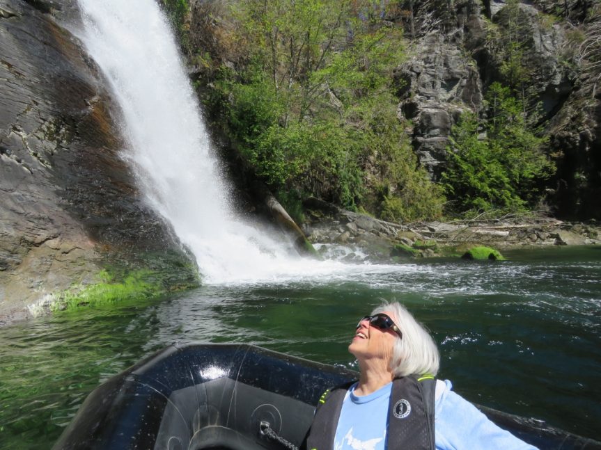
Our first stop is Refuge Cove. It’s early in the season and the harbor is empty. We clamber onto the dock and up to the store where we peruse the books, charts and other trivia offered for sale. Once everyone in Desolation Sound came here for mail, supplies and gossip. Continuing up Lewis Channel we enter Teakerne Arm, docking below the waterfall. The adventuresome ones hike up the path to Cassel Lake above the falls. Mike takes three of us for a cruise around the bay in the zodiac.
Back on board, Devon serves everyone a mug of a most delicious tea and cookies as we enter Calm Channel and pass the most northern point of Cortes Island, Bullock Bluff. Steering to port we enter Drew Passage between Read Island and the Rendezvous Islands. Passing Mayes Point we again steer to port and thread our way through Surge Narrows meticulously following the marked course between Read Island and Maurelle Island. It’s been a long and exciting day as we head to the far east side of Quadra Island and come to rest at Discovery Islands Lodge. Our skipper and his mate turn their hands to kitchen duty, and with the help of the lone person at the lodge soon have a salmon dinner on the table. In the morning we awake to freshly baked bread, porridge with many extras, and of course coffee.
On board again, Mike introduces us to the complicated intricacies of tides in Surge Narrows. We retrace our way through the Narrows heading north, cross Calm Channel, observe the site of Church House before beginning our ascent up Bute Inlet, passing Stuart Island on our port side.
Bute Inlet is 80 km long and averages 4 km wide with spectacular mountain vistas. The water is a deep blue and the land on both sides of the inlet is green with the native forests. Barbara Sherriff shows us maps of the geology and discusses the rocks that the trees conceal. As we travel up the inlet the water changes color as melting ice from the surrounding glaciers merge with the seawater. Toques, mitts, scarves and warm coats appear as the temperature drops. The wind off the numerous glaciers and massive ice fields is frigid.
After lunch we enter Bear Bay and we seem to be standing still as the tide is running against us. Mike takes us for a zip around the bay in the zodiac. Now the water is a milky grey turquoise. By late afternoon, mountains and glaciers that rise 9000 feet above sea level surround us. Mike maneuvers the boat to the far northeast corner where the Southgate River enters Bute Inlet and by looking to the north west we can see in the distance snow covered Mt. Waddington, the highest mountain in B.C. (13,186 ft.). Chuck, a guide from the Homathko Logging camp leads us up the river to the camp where we will spend the next two nights.
In the morning we hike in the surrounding area and instead of warning us about dangerous animals, Chuck says: “Do not disturb or frighten the wild life.” In the afternoon we take the zodiacs and explore the nearby Cumsack and Southgate rivers. The former has exquisite mountain reflections and the latter an old homestead that we explore.
Wednesday morning we begin the return trip down the inlet. En route Paul Jones buys fresh prawns off the boat that caught them and Devon serves them with garlic butter. Our last night is spent at another comfy Discovery Islands Lodge, tucked in a bay on Read Island off Sutil Channel.
On the 5th morning we travel south down the west side of Cortes Island. The day is grey, raining and we encounter a stormy southeastern wind. We duck in to Mansons Landing where very kind residents drive us to the local museum and then to Cortes Bay. Heading into the howling “southeaster” and towering seas, Mike and Devon alone take the Misty Isles down and around the most southern tip of Cortes Island, Sutil Point, to Cortes Bay. We board the vessel for a rough ride, battling 6 ft waves, until we reach the north end of Thulin Passage and the Copeland Islands protect us from the battering wind. We arrive in Lund harbor peacefully at 5:15 as planned.